Thanks to generous support from Esri, NAA can provide this opportunity
at no cost to you! Register for one, two, or all three!
Have questions? Email us at info@naturalareas.org.
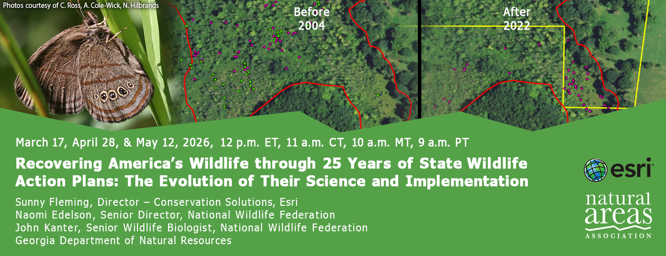
Over the past 25 years, State Wildlife Action Plans have evolved from foundational blueprints into comprehensive, science-based strategies that address a broader range of species, regional priorities, and conservation challenges. Since the establishment of the State Wildlife Grants program in 2000, every state has updated its plan on a regular cycle, with the most recent revisions completed in 2025.
In parallel, the GIS tools supporting these efforts have transformed how conservation work is planned, implemented, and communicated. Bringing State Wildlife Action Plans from strategy to action depends on collaboration among diverse partners and stakeholders. Modern Web GIS supports this work through shared data, visualization, and storytelling, using tools such as StoryMaps, Dashboards, and ArcGIS Hubs to communicate complex science and policy in clear and compelling ways.
This webinar series explores how advances in conservation science, policy, and spatial technology collectively shape today’s State Wildlife Action Plans. Participants will hear from state agency biologists and practitioners and will learn best practices for connecting expanded biological scope with holistic GIS strategies to support implementation, collaboration, and communication.
The first webinar in the series will consider the evolution of State Wildlife Action Plans and a greater need for collaboration across ecosystems and how GIS has and can continue to contribute to advancing communication, data collection, and demonstrating the impact.
Presenters:
Sunny Fleming, Director - Conservation Solutions, Esri
John Kanter, Senior Wildlife Biologist, National Wildlife Federation
Since the establishment of the State Wildlife Grants program in 2000, every state in the nation has created a blueprint of conservation actions for wildlife. These State Wildlife Action Plans are required to be updated every ten years with October 2025 the most recent version. Leading state agency biologists will share an overview showcasing the inclusion of plants, insects, and regional priorities to ensure recovering the full diversity of flora and fauna, and how you can support the implementation of your state’s action plan.
The third webinar will feature your peers who are using Esri's GIS tools to support planning efforts such as State Wildlife Action Plans. Modern Web GIS supports this work through shared data, visualization, and storytelling, using tools such as StoryMaps, Dashboards, and ArcGIS Hubs to communicate complex science and policy in clear and compelling ways. This program is practical and applied, offering real-world insights you can apply to your own work.
Presenters:
Sunny Fleming, Director - Conservation Solutions, Esri
Georgia Department of Natural Resources - Case Study Presenters:
Brett Albanese, Ph.D., Assistant Chief, Wildlife Conservation Section & State Wildlife Action Plan Coordinator, Georgia Department of Natural Resources
Dr. Brett Albanese is an Assistant Chief in the Wildlife Conservation Section of Georgia DNR and currently serves as Georgia’s SWAP Coordinator. Brett focused most of his career on the ecology and conservation of freshwater fishes and helped develop a Freshwater Biodiversity Program that focuses on surveys, monitoring and conservation action for SGCN fishes, mussels and crayfishes. Brett has worked for DNR since 2003 and contributed to Georgia’s 2005 and 2015 State Wildlife Action Plans.

Keith Bradley, State Botanist, Heritage Trust, Botany & Plant Conservation, Land, Water & Conservation Division, South Carolina Department of Natural Resources
Keith A. Bradley is State Botanist, Heritage Trust, Botany & Plant Conservation, Land, Water & Conservation Division, South Carolina Department of Natural Resources(SCDNR) specializing in plant species and ecosystems of the Southeastern United States and Caribbean. He is also an Affiliate Faculty of the University of South Carolina’s A.C. Moore Herbarium. He has been active in the regional conservation community for 30 years, working on a broad array of biological conservation research, land management, and planning issues.
Keith grew up in Miami, Florida, and his work in Florida on recovery of endangered species and their habitats has led to two awards from the U.S. Fish and Wildlife Service, including the Regional Leader in Recovery Award in 2008 and the Coastal Program Conservation Partnership Award in 2010. He is widely considered an expert on the flora of the southeast and has authored two publications, Trees of Appalachia: A Guide to Common Native Species and Wildflowers of Appalachia: A Guide to Common and Rare Native Species.
Naomi Edelson, Senior Director, National Wildlife Federation
Naomi is an inspirational leader in the wildlife conservation community who is gifted at building movements of people inspired to action. She is respected for convening coalitions and motivating teams for success, as well as being an innovator in the field, creating new practical tools and expert guidance. As Senior Director for Wildlife Partnerships at National Wildlife Federation, she leads their partnerships with state wildlife agencies and other state-based partners to secure greater funding and support to prevent wildlife from becoming endangered. On the federal side this includes the Recovering America’s Wildlife Act campaign (www.nwf.org/recoveringamericaswildlife). Before working with NWF, Naomi raised more than $1 billion U.S. dollars in new conservation funding through her work as the Teaming with Wildlife Director at the Association of Fish and Wildlife Agencies. She initiated and directed all aspects of Teaming with Wildlife, a national grassroots coalition of more than 6,000 groups focused on securing federal funding for state-level wildlife conservation. It is this effort that led to the establishment of the State Wildlife Action Plans and State and Tribal Wildlife Grants program.

Sunny Fleming, Director - Conservation Solutions at Esri
With a background in plant ecology and botany, Sunny Fleming has applied location intelligence throughout her career; from monitoring species in the field to helping state parks manage recreational assets across their systems. She continues to pursue her passion for the environment by now supporting others in applying location intelligence to their work.

John Kanter, CWB®, Senior Wildlife Biologist, National Wildlife Federation
With over 30 years of experience, John works to ensure that NWF programs reflect the best available science and latest practices in wildlife biology and management. Prior to joining NWF in 2017, John worked for 25 years at New Hampshire Fish and Game Department where he developed the state’s nongame and endangered wildlife section, growing it from a one-person program to a team of 10 biologists. By applying sound science and establishing effective public-private partnerships, his team restored populations of the Karner blue butterfly, roseate tern, Blanding’s turtle, New England cottontail and other at-risk species. As past chair and member of the Northeast Wildlife Diversity Technical Committee, John helped to establish the Northeast Regional Conservation Needs Grant program, which funded several multi-state conservation efforts aimed at preventing species from needing federal listing.

Liz Morata, GIS Analyst, Georgia Department of Natural Resources
Liz Morata is a wildlife biologist who specializes in spatial ecology and animal movement, currently working as a GIS analyst with the Georgia DNR Wildlife Conservation Section. She uses maps, data, and field experience to support conservation planning, wildlife monitoring, and statewide wildlife management efforts.

Dylan Severans, GIS Specialist, Georgia Department of Natural Resources
Dylan Severens has been with DNR since 2016, first as a GIS specialist for the fisheries section and later as supervisor for the GIS Team. He participates in most traditional outdoor activities and has a newfound interest in gardening.

Ross Winton, Westside Butterfly Species Lead, Endangered Species Recovery Section, Diversity Division, Wildlife Program, Washington Department of Fish and Wildlife
Ross Winton is a conservation entomologist with the Washington Department of Fish and Wildlife with an emphasis on imperiled butterflies. After receiving a B.S. in Wildlife Management and an M.S. in Entomology both from Montana State University he has sought to fuse these two fields and focus conservation actions on invertebrate taxa. He has worked in the wildlife management field for over two decades on both species and habitat conservation. From elk, sage grouse and bats to the tiniest blind cave invertebrates and tropical canopy species he has been blessed to serve as a conservation steward alongside many colleagues in wildlife conservation.
Support the people who manage our natural areas and protect biodiversity in perpetuity.